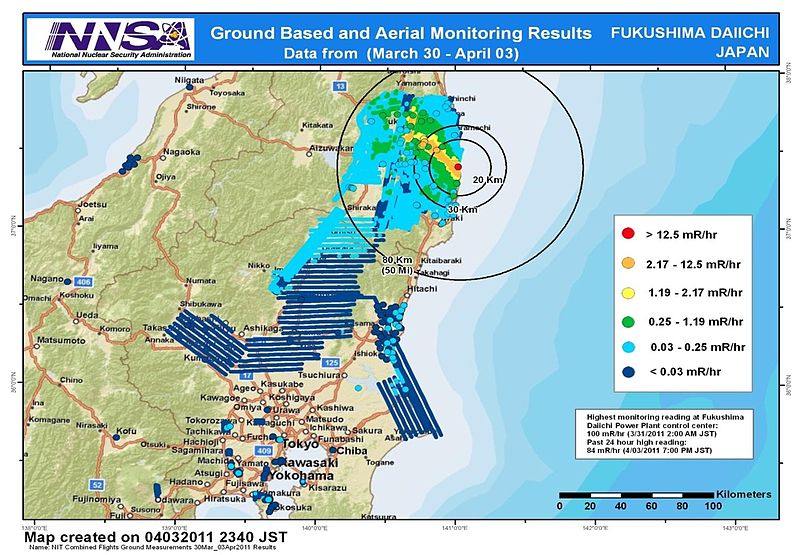
File:NIT Combined Flights Ground Measurements 30Mar 03Apr2011 results.jpg
Appearance

Cabirka muuqaalkaan: 800 × 555 pixels. Waxyaabaha kale xalinta: 320 × 222 pixels | 640 × 444 pixels | 1,024 × 710 pixels | 1,245 × 863 pixels.
Faylka asalka ah (1,245 × 863 pixels, weyninka faylka : 612 KB, nuuca MIME: image/jpeg)
Taariikhda faylka
Riix taariikhda/waqtiga si aad u argto faylka sida oo ahaa markiisa hore.
| Taariikhda/Waqtiga | Sawir yar | Cabirka | Isticmaale | Ka hadalka | |
|---|---|---|---|---|---|
| kan hadda | 09:36, 9 Abriil 2011 |  | 1,245 × 863 (612 KB) | Teofilo | cropped |
| 09:26, 9 Abriil 2011 |  | 1,920 × 1,080 (689 KB) | Teofilo | {{Information |Description ={{en|1=Combined results of 211 flight hours of aerial monitoring operations and ground measurements made by DOE, DoD and Japanese monitoring teams.}} |Source =4th slide of http://energy.gov/news/documents/AMS_Data_Ap |
Faylka lagu isticmaalay
waxyaabaha soo socda ee bog ayaa adeegsanaya faylkaan:
isticmaalka faylka aduunka
Wikisyada kale ee soosocda ayaa adeegsanaya faylka:
- Ku isticmaal bg.wikipedia.org
- Ku isticmaal de.wikipedia.org
- Ku isticmaal en.wikipedia.org
- Ku isticmaal en.wikibooks.org
- Ku isticmaal es.wikipedia.org
- Ku isticmaal it.wikipedia.org
- Ku isticmaal ja.wikipedia.org
- Ku isticmaal pl.wikipedia.org
- Ku isticmaal pt.wikipedia.org
- Ku isticmaal sr.wikinews.org
- Ku isticmaal th.wikipedia.org
- Ku isticmaal tr.wikipedia.org
- Ku isticmaal www.wikidata.org
- Ku isticmaal zh.wikipedia.org


