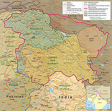
File:Kashmir Region (2020 skirmish locations).jpg
Appearance

Cabirka muuqaalkaan: 604 × 599 pixels. Waxyaabaha kale xalinta: 242 × 240 pixels | 484 × 480 pixels | 774 × 768 pixels | 1,033 × 1,024 pixels | 1,579 × 1,566 pixels.
Faylka asalka ah (1,579 × 1,566 pixels, weyninka faylka : 1.27 MB, nuuca MIME: image/jpeg)
Taariikhda faylka
Riix taariikhda/waqtiga si aad u argto faylka sida oo ahaa markiisa hore.
| Taariikhda/Waqtiga | Sawir yar | Cabirka | Isticmaale | Ka hadalka | |
|---|---|---|---|---|---|
| kan hadda | 18:45, 24 Juun 2020 |  | 1,579 × 1,566 (1.27 MB) | MarkH21 | Removed the Daulat Beg Oldi circle as not being an actual location of conflict; added the Hot Springs, Chang Chenmo Valley circle as an actual location of conflict. |
| 02:01, 24 Juun 2020 |  | 1,579 × 1,566 (1.27 MB) | MarkH21 | Uploaded a work by United States Central Intelligence Agency, MarkH21 from [https://legacy.lib.utexas.edu/maps/middle_east_and_asia/kashmir_region_2004.jpg Map of Kashmir region] created by the US Central Intelligence Agency, 2004; altered by MarkH21 with UploadWizard |
Faylka lagu isticmaalay
waxyaabaha soo socda ee bog ayaa adeegsanaya faylkaan:
isticmaalka faylka aduunka
Wikisyada kale ee soosocda ayaa adeegsanaya faylka:
- Ku isticmaal af.wikipedia.org
- Ku isticmaal ca.wikipedia.org
- Ku isticmaal en.wikipedia.org
- Ku isticmaal es.wikipedia.org
- Ku isticmaal fa.wikipedia.org
- Ku isticmaal fr.wikipedia.org
- Ku isticmaal he.wikipedia.org
- Ku isticmaal ja.wikipedia.org
- Ku isticmaal ka.wikipedia.org
- Ku isticmaal ml.wikipedia.org
- Ku isticmaal ne.wikipedia.org
- Ku isticmaal pnb.wikipedia.org
- Ku isticmaal pt.wikipedia.org
- Ku isticmaal ru.wikipedia.org
- Ku isticmaal simple.wikipedia.org
- Ku isticmaal ta.wikipedia.org
- Ku isticmaal te.wikipedia.org
- Ku isticmaal th.wikipedia.org
- Ku isticmaal tr.wikipedia.org
- Ku isticmaal uk.wikipedia.org
- Ku isticmaal ur.wikipedia.org
- Ku isticmaal vi.wikipedia.org
- Ku isticmaal www.wikidata.org
- Ku isticmaal zh.wikipedia.org


