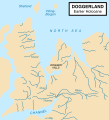
File:Doggerland.svg
Appearance

Size of this PNG preview of this SVG file: 545 × 600 pixels. Waxyaabaha kale xalinta: 218 × 240 pixels | 436 × 480 pixels | 698 × 768 pixels | 930 × 1,024 pixels | 1,860 × 2,048 pixels.
Faylka asalka ah (SVG file, nominally 545 × 600 pixels, file size: 165 KB)
Taariikhda faylka
Riix taariikhda/waqtiga si aad u argto faylka sida oo ahaa markiisa hore.
| Taariikhda/Waqtiga | Sawir yar | Cabirka | Isticmaale | Ka hadalka | |
|---|---|---|---|---|---|
| kan hadda | 18:59, 19 Oktoobar 2014 |  | 545 × 600 (165 KB) | Ras67 | frame removed |
| 13:06, 24 Juun 2011 |  | 348 × 383 (132 KB) | Ciaurlec | Changed colours to uniform all the palaeogeographic maps | |
| 00:52, 22 Febraayo 2009 |  | 348 × 383 (125 KB) | Maxí | {{Information |Description={{en|1=An image of the area known as Doggerland which connected the British Isles and the European continent. Loosely based on two images, found [http://www.bevpease.force9.co.uk/p.Flood_files/image002.jpg here] and [http://soga |
Faylka lagu isticmaalay
waxyaabaha soo socda ee bog ayaa adeegsanaya faylkaan:
isticmaalka faylka aduunka
Wikisyada kale ee soosocda ayaa adeegsanaya faylka:
- Ku isticmaal ar.wikipedia.org
- Ku isticmaal arz.wikipedia.org
- Ku isticmaal be.wikipedia.org
- Ku isticmaal ca.wikipedia.org
- Ku isticmaal cs.wikipedia.org
- Ku isticmaal cy.wikipedia.org
- Ku isticmaal da.wikipedia.org
- Ku isticmaal de.wikipedia.org
- Ku isticmaal el.wikipedia.org
- Ku isticmaal en.wikipedia.org
- Ku isticmaal eo.wikipedia.org
- Ku isticmaal es.wikipedia.org
- Ku isticmaal et.wikipedia.org
- Ku isticmaal eu.wikipedia.org
- Ku isticmaal fa.wikipedia.org
- Ku isticmaal fi.wikipedia.org
- Ku isticmaal frr.wikipedia.org
- Ku isticmaal fr.wikipedia.org
- Ku isticmaal fr.wiktionary.org
- Ku isticmaal he.wikipedia.org
- Ku isticmaal hr.wikipedia.org
- Ku isticmaal hu.wikipedia.org
- Ku isticmaal hy.wikipedia.org
View more global usage of this file.

